|
|
| |
|
|
| |

- Covers
approximately 40,000 acres.
- Spans
seven townships in CT and NY.
- Length
20 miles, elevation drop 962 ft.
- Watershed
population: 65,587 people (1990 census).
- Major
tributaries: Silvermine River, Comstock Brook.
- Public
reservoirs on upper Silvermine & Comstock.
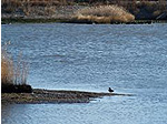
- Good
recreational fishing at many sites.
- Major
oyster beds at mouth, in Long Island Sound.
- Important
transportation corridor (US Rte. 7).
|
| |
 |
|
Monitoring Water Quality in the Norwalk River
The Norwalk River Watershed Association provides funding
to the Harbor Watch/River Watch Program for the on-going
monitoring of water quality throughout the Norwalk River.
Harbor Watch/River Watch is based out of Earthplace
in Westport, CT and provides NRWA with periodic water
quality reports (available for download below), as well
as presents a summary of the year's findings at our
annual meeting each Spring.
Download Water Quality Reports
|
| |
 |
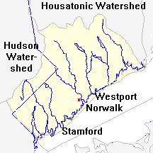 The
Norwalk River watershed lies in an area that's bounded
by the Housatonic River watershed on the north and east,
the Hudson River watershed on the west, and Long Island
Sound on the south. Within this area (shown in here
in yellow), the Norwalk is one of several rivers that
flow SSE into the Sound.
The
Norwalk River watershed lies in an area that's bounded
by the Housatonic River watershed on the north and east,
the Hudson River watershed on the west, and Long Island
Sound on the south. Within this area (shown in here
in yellow), the Norwalk is one of several rivers that
flow SSE into the Sound.
Its neighbor to the east is the Saugatuck River, which
arrives at the Sound in Westport. On the southwest
its neighbor is the small Fivemile River (not shown on
this map) and the Rippowam, which drains the area above
the source of the Fivemile and brings its water down to
Stamford. Above the Rippowam, the land west of the
Norwalk River drains into the Hudson via the Titicus River
(in the greyed-in part of the map). |
 |
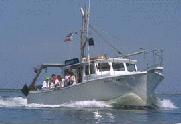
The
Norwalk River enters Long Island Sound at Veteran's Park
in South Norwalk, 40 miles northeast of Manhattan.
At the river's mouth is a tidal estuary and harbor used
by hundreds of pleasure and fishing boats. Marine
life is abundant, and oyster fishing has been an important
activity going back to pre-colonial times.
 Educational tours of the harbor are offered by the Maritime
Aquarium, and an annual Oyster Festival is sponsored
by the Norwalk Seaport Association. One mile offshore
is a chain of islands which serve as a wildlife refuge
and, in specific areas, as a popular destination for boaters.
One particular attraction is the historic
Sheffield lighthouse.
Educational tours of the harbor are offered by the Maritime
Aquarium, and an annual Oyster Festival is sponsored
by the Norwalk Seaport Association. One mile offshore
is a chain of islands which serve as a wildlife refuge
and, in specific areas, as a popular destination for boaters.
One particular attraction is the historic
Sheffield lighthouse. |
 |
| Upriver
from Norwalk, one first reaches the town of Wilton and
then the town of Ridgefield. These two towns, combined
with the city of Norwalk, contain more than 78 percent
of the watershed. Their western neighbors, New Canaan
and Lewisboro (NY), contain nearly 16 percent, entirely
within the sub-watershed of the Norwalk River's largest
tributary, the Silvermine River. The towns to the
east, Weston and Redding, contain just 6 percent of the
watershed. This is shown in more
detail here. A wealth of online information
is available concerning the upriver communities of Wilton,
Ridgefield, Lewisboro, and Redding. For the entire county
of Fairfield CT, an excellent online resource is the blue
pages. |
| |
 |
| Two-thirds
of the households in the watershed -- mostly within the
urban and village districts -- obtain their water from
public water supply systems. Most of the rest get their
water from private drilled wells, and a small number use
private dug wells. Sewage disposal is predominantly
by public sewage systems in the urban areas and by private
septic systems in the more rural and suburban areas. The
ratio for the entire watershed is 56 percent of all households
using public sewage disposal systems. This is shown
graphically here. |

 |
| Many
pollutants reach the Norwalk River through stormwater
runoff from urban zones, roads, and other impervious areas.
Some common misconceptions about water runoff are discussed
by the Natural Resources Defence Council, and runoff from roads is described by the Environmental Protection Agency.
Another EPA document describes the economic benefits of controlling stormwater runoff. Technical details
on this subject are available from the North Carolina
State University concerning runoff from: urban areas,
roads, construction projects, and industrial
sites. |
| |
 |
| The
Norwalk River's banks have undergone human modification
in many places, often to the detriment of the river's
water quality and posing threats to the plant and animal
life that lives along the river. The importance
of these streamside "riparian" areas is discussed here. In June 1998, several local groups joined forces to
restore a section of the Norwalk River's riverbank in
Wilton to a more natural condition. (See article here.) Similar projects are being planned for other points
in the watershed. "Toolbox"
of riparian buffer management developed by the Long Island
Sound NEP. Check our events calendar
to see what has been scheduled. |
| |
 |
The
most serious problem in the recent water-quality tests
on the Norwalk River is the presence of bacteria, part
of which may come from unmaintained or malfunctioning
septic systems. Background information about septic-system
maintenance can be found here.
Questions about local regulations and practices should
be directed to local health departments. For an in-depth
explanation of the subject, various books
can be consulted. Some technical details are available
online about septic systems, and on the related, important subject of underground storage
tanks. Alternate
Sewage Treatment Systems- White Paper (PDF)
Throughout the Norwalk River watershed, a new lending
arrangement termed a watershed improvement
loan is available to provide local property owners
with another method for handling certain types of critical
improvements, such as repairs to malfunctioning septic
systems or removal or replacement of in-ground fuel tanks.
|
| |
 |
| Discharges
from "point sources" such as wastewater treatment plants
and industrial discharge pipes are not nearly as severe
a problem as they were ten or twenty years ago.
But despite the many improvements, some serious areas
of concern remain. |
| One
of the most dramatic changes that's currently taking place
within the Norwalk River watershed (and throughout much
of North America) is the displacement of the native plant
life by aggressive invasive species. Read more about
specific Invasive threats in our Invasive
Species Section. Also available: A list of Invasive
Species in the Norwalk River Watershed are listed here.
Multiple links to Invasive Species Information is listed
on our links
page. |
| |
 |
|
Flooding
is a natural process for rivers, and it produces many
beneficial side effects such as the distribution of
fresh water over a wide area to replenish groundwater
supplies that are critical for the private wells that
many households depend upon. But in a congested region
like Fairfield County, floods can also pose a great
threat to life and property.
The Norwalk River has not had a significant flood since
1955. A modern repeat of the
1955 flood would do over $21 million in damage along
the river, according to a Connecticut study, and the
State has identified the region as a "high risk basin
in immediate need of better flood control management
and hazard mitigation." The immediate danger can
be reduced by adopting a flood warning system (see
article), by increasing building setbacks from the
river, and by setting aside as open space property adjacent
to or upland of the river system in order to reduce
impervious surfaces and increase absorption.
Do
your part...Excess leaves can clog culverts, fill ponds
or the backside of a dam, and make the river shallower
and more prone to flooding or the need for expensive
dredging. Property owners should let anyone who works
with them or for them know that this material should
not be blown or dumped into any river, pond, or wetland.
No matter which waterway or wetland is a dumping target,
dumping in those sensitive areas can have serious consequences
(see article).
|
|
|
|
|